Visual Place Recognition: Finding Your Location from a Picture
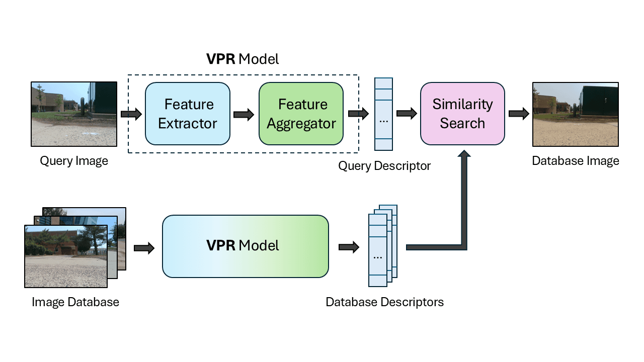
Visual Place Recognition (VPR) answers "Where am I?" by matching a live camera image to a database of pre-recorded pictures. It's a visual GPS for robots and self-driving cars to find their position when GPS is unreliable, like in cities or indoors.
WHY IT EXISTS: Robots and autonomous systems need to know where they are to navigate. GPS is often unavailable or inaccurate, especially in cities with tall buildings ("urban canyons") or indoors. VPR provides a way to determine location using only a camera, a much more universally available sensor.
THE MENTAL MODEL: Think of VPR as a game of visual "memory" played by a robot. It has an album of photos, each tagged with a location. When it takes a new picture of its surroundings, it quickly searches its album to find the photo that looks the most similar, thereby inferring its current location from the tag on the matching photo.
HOW IT WORKS: The modern approach uses a machine learning model trained to extract a compact set of features, or a "descriptor," from an image. This descriptor encodes the essential geographic information. To find its location, the system computes the descriptor for the current camera image and then searches the database for the pre-computed descriptor with the smallest distance, indicating the most similar place.
WHEN TO USE IT: Use VPR for localization tasks in robotics and autonomous driving, especially as a supplement or backup to GPS. It's effective in environments that have been previously mapped with a database of images. This applies to both outdoor urban scenes and indoor environments like warehouses or airports.
WHEN NOT TO USE IT: VPR is not a general-purpose object recognition system; it matches whole scenes. It struggles in environments that change dramatically and unpredictably, or in places with no distinct visual features, like a long, uniform hallway or an open desert. It also requires a pre-built, up-to-date image database of the area to function.
ONE CANONICAL EXAMPLE: A self-driving car in a city center loses its GPS signal. Its camera captures an image of a unique storefront and intersection. The VPR system converts this image into a feature descriptor and matches it against its pre-loaded database of images from the city, finding a near-exact match. The system now knows its precise location is at that intersection and can continue navigating safely without GPS.
Read the original → en.wikipedia.org
Get five bites like this every day.
Tezvyn delivers a daily feed of 60-second tech bites with quizzes to lock in what you learn.